
Buying property in Florida? Already own a home in Florida and curious how flood zones change risk tolerance? Flood zones are crucial considerations for homeowners and builders, especially in areas prone to flooding like Florida’s coastline. These are vital topics we go over with every buyer looking at homes for sale in Mexico Beach, Port St. Joe, Cape San Blas, St. George Island, and Panama City Beach. Below you’ll find vital information that you MUST know when considering home ownership in Florida, including a list of helpful flood map resources as well as 5 important facts for coastal living.
First off, you’ll want to be well versed in the flood zone verbiage and differences. Here’s a breakdown of the key differences between flood zones X, AE, and VE, and how they affect building a home:
- Flood Zone X (Preferred Risk Zone):
- Flood Zone X is considered to be an area of minimal flood risk.
- Properties in Zone X are not typically required to have flood insurance, although it’s still recommended in case of unexpected events.
- Building regulations in Zone X are usually less stringent compared to higher risk zones, though local building codes may still require certain flood-resistant construction practices.
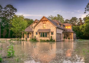
- Flood Zone AE (Base Flood Elevation Zone):
- Flood Zone AE is considered to have a moderate to high risk of flooding.
- Homes in Zone AE are typically subject to more stringent building codes and regulations to mitigate flood damage.
- Properties in Zone AE are often required to have flood insurance if they have a federally backed mortgage.
- The elevation of the property in relation to the Base Flood Elevation (BFE) is a key factor in determining insurance rates and building requirements. If the property’s lowest floor is below the BFE, the homeowner may face higher insurance premiums and may be required to elevate the home or take other flood mitigation measures.
- Flood Zone VE (Coastal High Hazard Zone):
- Flood Zone VE is the most high-risk flood zone, specifically designated for coastal areas.
- Properties in Zone VE are subject to the strictest building codes and regulations to mitigate against storm surge and high-velocity wave action.
- Homes in Zone VE are typically required to be elevated on pilings or columns to reduce the risk of damage from storm surges.
- Flood insurance is almost always required for properties in Zone VE, and premiums can be significantly higher due to the increased risk.
While flood Zone X indicates minimal risk, Zones AE and VE represent progressively higher levels of risk. The higher the risk zone, the more stringent the building codes and insurance requirements become. When building a home in any flood zone, it’s essential to adhere to local building codes, elevate the structure if necessary, and consider flood insurance to protect against potential losses.
Here are five key reasons why potential home buyers should be concerned about flood zones before purchasing a home by Florida’s coastline:
- Property Damage Risk: Homes located in flood-prone areas are at a higher risk of sustaining damage from floods, storm surges, and other coastal hazards. Flood damage can be extensive and costly to repair, potentially leading to financial losses for homeowners.
- Insurance Costs: Properties located in flood zones typically require flood insurance, which can be expensive, especially in high-risk areas. Home buyers need to factor in the cost of flood insurance premiums when considering the affordability of a coastal property.
- Resale Value: Homes in flood-prone areas may have lower resale values due to the perceived risk of flooding. Potential buyers may be hesitant to purchase properties with a history of flooding or located in high-risk flood zones, impacting the resale value and marketability of the home.
- Safety Concerns: Flood-prone areas pose safety risks to homeowners, their families, and their belongings. Floods can disrupt daily life, cause evacuations, and even endanger lives in extreme cases. Home buyers should prioritize safety considerations when evaluating properties in flood zones.
- Regulatory Requirements: Properties located in flood zones are subject to regulatory requirements and building codes aimed at mitigating flood risks. Compliance with these regulations may entail additional costs for homeowners, such as elevating the home, installing flood-resistant materials, or obtaining permits for renovations or improvements.
By considering these factors and conducting thorough due diligence on flood zones before purchasing a home, potential buyers can make informed decisions to protect their investment and ensure their safety and financial well-being in Florida’s coastal areas. Additionally, here are 5 resources you can use right now to learn more about flood risk and see the flood maps for each property address:
- FEMA Flood Map Service Center: The Federal Emergency Management Agency (FEMA) provides flood maps and information through its Flood Map Service Center. You can search for flood maps by address, view flood risk profiles, and access other flood-related resources. https://msc.fema.gov/portal/home
- National Flood Hazard Layer (NFHL): The NFHL is a database maintained by FEMA that contains flood hazard mapping products, including Flood Insurance Rate Maps (FIRMs) and Flood Insurance Studies (FIS). Users can access flood hazard data and maps for various areas across the United States. https://www.fema.gov/flood-maps/national-flood-hazard-layer
- FloodSmart.gov: FloodSmart.gov is FEMA’s official website for flood awareness and education. It provides resources for understanding flood risks, purchasing flood insurance, and accessing flood mapping tools. Users can find flood maps and information specific to their location. FloodSmart.gov
- USGS National Water Information System (NWIS): The U.S. Geological Survey (USGS) offers the National Water Information System (NWIS), which provides real-time and historical water data, including streamflow data and flood monitoring information. Users can access flood maps and hydrologic data for different areas. https://waterdata.usgs.gov/nwis
- Local Government Websites: Many local government websites provide flood zone maps and information for their respective jurisdictions. Check the website of your city or county’s planning department, emergency management agency, or floodplain management office for local flood maps and resources.Gulf County GIS Mapping: https://www.gulfcounty-fl.gov/county_government/geographic_information_systems___gis_Bay County GIS Mapping: https://gis.baycountyfl.gov/bayview/Walton County GIS Mapping: https://waltongis.maps.arcgis.com/apps/webappviewer/index.html?id=03358c36fd584c6ab6492a7c4d2b0e0eFranklin County GIS Mapping: https://qpublic.schneidercorp.com/Application.aspx?AppID=816&LayerID=14540&PageTypeID=1&PageID=6404

By utilizing these website resources, homeowners, home buyers, and other stakeholders can access valuable flood zone maps and information to better understand flood risks and make informed decisions related to floodplain management, insurance, and property development. You’ll also want to know about Florida’s CBRA zone (Coastal Barrier Resources Act) and how this also influences property ownership! Read more about the CBRA zone here https://callthepeevys.com/coastal-barrier-resources-act-explained/
Do you have more questions about property flood zones in the counties Gulf, Bay, Franklin, and Walton county of Florida? Send us a message with your particular questions and/or properties of interest below.
